Social Icons

Pages

Thursday, December 31, 2009

Zygmunts Column

Zygmunts Column built in 1644 is one of Warsaws most famous landmarks and one of the oldest secular monuments in northern Europe. It is also called as Sigismunds Column. The column and statue commemorate King Zygmunt III Waza, who in 1596 had moved Poland capital from Krakow to Warsaw.

Zygmunts ColumnBuilt between 1643 and 1644, the column was constructed on the orders of Zygmunts son and successor, King Wladyslaw IV Vasa. It was designed by the Italian-born architect Constantino Tencalla and the sculptor Clemente Molli, and cast by Daniel Tym. The Zygmunts Column was modelled on the Italian columns in front of Basilica di Santa Maria Maggiore, and the Column of Phocas in Rome.

In 1681 the monument was surrounded with a wooden fence, which was later replaced with a permanent iron fence. The marble column itself was renovated many times in the next few centuries. In 1854 the monument was surrounded with a fountain featuring marble tritons sculpted by the German, August Kiss.

In 1863 the column was renovated somewhat again, but still needed work, and between 1885 and 1887 it was replaced with a new column of granite. Between 1927 and 1930, the monument was again renovated, and was restored to its original appearance when the fountain and the fence around it were removed.

On September 1, 1944, during the Warsaw Uprising, the monument was demolished by the Germans, and its bronze statue was badly damaged. After the war the statue was repaired, and in 1949 it was set up on a new column, made of granite form the Strzegom mine, a couple of meters from the original site. The original broken pieces of the column can still be seen lying next to the Royal Castle.

ZygmuntPedestal FacingOn the Corinthian column 8.5 m high, a sculpture of the King, 2.75-meter high, in archaistic armour is placed. Sigismund Column now stands at 22 meters and is adorned by four eagles. The king is dressed in armor and carries a cross in one hand and wields a sword in the other.

Wednesday, December 30, 2009

Kravanh Mountains

The Kravanh Mountains, or literally Cardamom Mountains is a mountain range in the south west of Cambodia. The highest elevation of the Cardamom Mountains is Phnom Aural at 1,813 metres or 5,948 ft high. This is also Cambodia's highest peak. The mountain range extends along a southeast-northwest axis, and is continued to the southeast by the Damrei Mountains and to the northwest by an extension into Thailand territory known as the Soi Dao Mountains. The southern boundary of the Cardamoms is in Koh Kong Province and the northern boundary is in Veal Veang District in Pursat Province.

Koh Kong LoggingThis range of mountains formed one of the last strongholds of the Khmer Rouge and many parts are largely inaccessible. The inaccessibility of the hills helped to preserve the area the mountains now form an endangered ecoregion. The mountains contain many jar sites scattered around the mountains. The jars are a unique feature to the mountain. They are 60 cm high and carry the bones of deceased Cambodians. Local legends suggest the bones are the remains of Cambodian royalty.

TigerThe mountain range is home to fourteen endangered and threatened mammal species including the Asian elephant, Indochinese Tiger, Malayan sun bear and Pileated gibbon, Irrawaddy and humpback dolphins, and half of Cambodia’s bird species. It is the last place on earth with Siamese crocodiles and is the only habitat remaining in Cambodia for the nearly extinct batagur baska or Royal turtle.

The population of the Cardamom Mountain Range is extremely poor, and threats to the biological diversity of the region include habitat loss due to illegal logging, wildlife poaching, and forest fires caused by slash-and-burn agriculture. Among the international conservation organizations working in the area are Wildlife Alliance, Conservation International, Fauna and Flora International and WWF (World Wide Fund for Nature).

Dense tropical rain forest prevails on their western slopes, which annually receive from 150 to 200 inches or 3,800–5,000 mm of rainfall. By contrast only 40 to 60 inches or 1,000 to 1,500 mm fall on the wooded eastern slopes in the rain shadow facing the interior Cambodian plain. On their slopes cardamom and pepper are still grown commercially.

Tourism is relatively new to the area. In 2008, Wildlife Alliance launched a community-based ecotourism program in the village of Chi Phat, marketed as the gateway to the Cardamoms. However the number of international visitors remains very small in comparison to the tourism development of Angkor Wat in Siem Reap, or Phnom Penh.

Tuesday, December 29, 2009

Great Barrier Reef

The Great Barrier Reef is the world's biggest coral reef system composed of over 2,900 individual reefs and 900 islands stretching for over 2,600 kilometres / 1,600 miles over an area of approximately 344,400 square kilometres / 133,000 sq miles. The reef is located in the Coral Sea, off the coast of Queensland in northeast Australia.

Great Barrier ReefThe Great Barrier Reef can be seen from outer space and is the world's biggest single structure made by living organisms. This reef structure is composed of and built by billions of tiny organisms, known as coral polyps. The Great Barrier Reef supports a wide diversity of life, and was selected as a World Heritage Site in 1981. CNN has labeled it one of the 7 natural wonders of the world. The Queensland National Trust has named it a state icon of Queensland.

A large part of the reef is protected by the Great Barrier Reef Marine Park, which helps to limit the impact of human use, such as overfishing and tourism. Other environmental pressures to the reef and its ecosystem include water quality from runoff, climate change accompanied by mass coral bleaching, and cyclic outbreaks of the crown-of-thorns starfish.

The Great Barrier Reef has long been known to and utilised by the Aboriginal Australian and Torres Strait Islander people, and is an important part of local groups' cultures and spirituality. The reef is a very popular destination for tourists, especially in the Whitsundays and Cairns regions. Tourism is also an important economic activity for the region. Fishing also occurs in the region, generating Australia 1 billion dollar per year.

The Great Barrier Reef reaches from Torres Strait in the north to the unnamed passage between Lady Elliot Island and Fraser Island in the south. Lady Elliot Island is located 1,915 km / 1,190 miles southeast of Bramble Cay as the crow flies.The Great Barrier Reef supports a diversity of life, including many vulnerable or endangered species, some of which may be endemic to the reef system. Thirty species of whales, dolphins, and porpoises have been recorded in the Great Barrier Reef, including the dwarf minke whale, Indo-Pacific humpback dolphin, and the humpback whale. Large populations of dugongs live there.

Six species of sea turtles come to the reef to breed – the green sea turtle, leatherback sea turtle, hawksbill turtle, loggerhead sea turtle, flatback turtle, and the olive ridley. Fifteen species of seagrass in beds attract the dugongs and turtles, and provide a habitat for fish. The most common genera of seagrasses are Halophila and Halodule. Saltwater crocodiles live in mangrove and salt marshes on the coast near the reef. Nearly 125 species of shark, stingray, skates or chimera live on the reef.

Green Sea TurtleBlue Linckia Starfish215 species of birds including 22 species of seabirds and 32 species of shorebirds are attracted to the reef or nest or roost on the islands, including the white-bellied sea eagle and roseate tern. Most nesting sites are on islands in the northern and southern regions of the Great Barrier Reef, with 1.4-1.7 million birds using the sites to breed. Seventeen species of sea snake live on the Great Barrier Reef.

More than 1,500 species of fish live on the reef, including the clownfish, red bass, red-throat emperor, and several species of snapper and coral trout. Forty-nine species are known to mass spawn, with eighty-four other species found on the reef spawning elsewhere in their range. Four hundred species of corals, both hard corals and soft corals are found on the reef. The majority of these spawn gametes, breeding in mass spawning events that are controlled by the rising sea temperatures of spring and summer, the lunar cycle, and the diurnal cycle.

Thursday, December 24, 2009

Casa Loma

Casa Loma is now a museum and landmark in uptown Toronto, constructed in the Gothic Revival style. It was originally a residence for financier Sir Henry Mill Pellatt. Casa Loma was constructed over a three-year period from 1911-1914. The architect of the mansion was E. J. Lennox, who was responsible for the designs of several other city landmarks.

In 1903 Sir Henry Pellatt purchased 25 lots from developers Kertland and Rolf. Sir Henry commissioned Canadian architect E.J. Lennox to design Casa Loma with construction beginning in 1911, starting with the massive stables, potting shed and Hunting Lodge a few hundred feet north of the main building. The Hunting Lodge is a two storey 4,380 square foot house. The house cost approximately 3.5 million dollars and took a team of 300 workers three years to build from start to finish. At 98 rooms, it was the largest private residence in Canada. Notable amenities included an elevator, an oven large enough to cook an ox, two vertical passages for pipe organs, central vacuum, two secret passages in Sir Henry's ground-floor office and three bowling alleys.

Most of the third floor was left unfinished, and today serve as the Regimental Museum for The Queen's Own Rifles of Canada. Pellatt joined the Regiment as a Rifleman and rose through the ranks, eventually becoming the Commanding Officer. He was knighted for his dedication to the Regiment. Later, Pellatt served as the Honorary Colonel and was promoted to Major-General upon retirement.

Casa Loma has five acres of gardens. An underground tunnel connects Casa Loma to the Hunting Lodge and to the Stables Garage, Potting Shed, Stalls, Carriage Room and Tack Rooms. Sir Henry imported artisans from Europe to design much of the furniture and other features of the castle.

Casa Loma is on Austin Terrace, at the north end of Spadina Road on an escarpment above Davenport Road. Davenport runs along the bottom of the escarpment which was the shoreline of Lake Iroquois, the predecessor of Lake Ontario. Casa Loma affords views down the escarpment and Spadina Avenue into the heart of Toronto. Stables located at 330 Walmer road and Hunting Lodge at 328 Walmer road.

Due to its unique architectural character in Toronto, Casa Loma has been a popular location for movies and TV. For example, it has served as a location for movies such as X-Men, Strange Brew, Chicago, The Tuxedo, and The Pacifier.

Tuesday, December 22, 2009

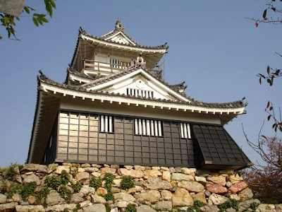
Hamamatsu Castle

Hamamatsu Castle is a Japanese castle reconstructed in hirayama-style. It was the seat of various fudai daimyo who ruled over Hamamatsu Domain, Totomi Province, in what is now central Hamamatsu, Shizuoka Prefecture, Japan. It is also called Shussei Castle.

Hamamatsu CastleThe origins of Hamamatsu castle is unclear however it appears that a fortification was built on this site by Imagawa Sadatsuke, the 4th head of the Enshu Imagawa clan from around 1504-1520. The early castle was called Hikuma Castle and was entrusted to Imagawa retainer Iio Noritsura. After the fall of the Imagawa Yoshimoto at the Battle of Okehazama, Iio Tsuratatsu rebelled against Imagawa Ujinao, but was defeated. However, the greatly weakened Imagawa clan was unable to withstand the combined forces for Tokugawa Ieyasu from Mikawa and Takeda Shingen from Kai.

The former Imagawa territories in Totomi were divided between the Tokugawa and Takeda in 1568, with Tokugawa Ieyasu obtaining Hamamatsu. He relocated his headquarters from Okazaki Castle to Hamamatsu in 1570, and spent the following 17 years there.

Tokugawa Ieyasu renovated and greatly expanded the castle, which he renamed Hamamatsu Castle in 1577. He relocated to Sunpu Castle in 1586, entrusting Hamamatsu Castle to Horio Yoshiharu, who was followed by his son Horio Tadauji. After the Battle of Sekigahara, Hamamatsu was briefly ruled by Tokugawa Yorinobu, followed by a succession of fudai daimyō through the remainder of the Edo period. Contemporary records indicate that the castle was never built with a tenshukaku-style keep. Throughout its history, a two-story yagura located within the second bailey served as a substitute keep.

HamamatsuIeyasu Tokugawa StatueWith the Meiji Restoration, the remaining military structures of the castle were destroyed, outer moats filled in, and outer baileys sold off. The central portion of the castle remained owned by the city as a park. In 1958, a faux donjon was constructed out of reinforced concrete on top of the original stone palisade built by Tokugawa Ieyasu. This palisade is known as the "Norzura-zumi" referring to the method used to fit the stones together.

The reconstructed structure has three stories with an observatory affording a view of the Pacific Ocean at the topmost level. There is a small museum inside which houses armor and other relics of Tokugawa clan, as well as a miniature model of how the city might have looked at the start of the Edo period. Surrounding the museum is Hamamatsu Castle Park which is planted with numerous sakura trees. A large bronze statue of Tokugawa Ieyasu also stands in the park.

Malbork Castle

The Castle in Malbork was built in Prussia by the Teutonic Order, a German Roman Catholic religious order as an Ordensburg. The Order named it Marienburg literally Mary Castle. The town which grew around it was also named Marienburg since 1945 it is known as Malbork.The castle is a classic example of a medieval fortress, and is the world’s largest brick gothic castle. UNESCO listed the castle and its museum as World Heritage Sites in December 1997 as Castle of the Teutonic Order in Malbork. It is one of two World Heritage Sites in the region with origins in the Teutonic Order. The other is the Medieval Town of Torun, founded in 1231 as the site of the castle Thorn.

Malbork CastleThe castle was founded in 1274 by the Teutonic Order during their government of Prussia and is located on the Southeastern bank of the river Nogat. It was named Marienburg after the Virgin Mary, patron saint of the Order.

After the First Partition of Poland in 1772 the town became part of the Kingdom of Prussia province of West Prussia. At that time the rather neglected castle was used as poorhouse and barracks for the Prussian Army. In 1794 David Gilly, a Prussian architect and head of the Oberbaudepartement, was ordered to make a structural survey of the castle, to decide about its future use or even its complete demolition. Gilly's son, Friedrich Gilly, produced several engravings of the castle and its architecture, which he exhibited in Berlin and had published by Friedrich Frick from 1799 to 1803. These engravings led to a rediscovery of the castle and the history of the Teutonic Knights by the Prussian public.

Johann Dominicus Fiorillo published a recension of the engravings on 12 February 1803. Fiorillo said he hoped the engravings would encourage public interest, and Max von Schenkendorf critizised the defacement of the castle. Throughout the Napoleonic period the castle was used as a hospital and arsenal, but after Prussia was liberated again, it became a symbol of Prussian history and national consciousness. Reconstruction began after 1816 on the initiative of Theodor von Schon, Oberprasident of West Prussia, and lasted with varying intensity until World War II started.

With the rise of Adolf Hitler to power in the early 1930s the Nazis began using the site for annual pilgramages by both the Hitler Youth and the League of German Girls. It was the Teutonic Castle at Marienburg, Malbork that served as the blue print for the Order Castles of the Third Reich.

Malbork CastleMalbork CastleWorld War II combat in 1945 destroyed more than half of the castle. At the conclusion of World War II, the castle, together with the surrounding city, became part of Poland. A fire in 1959 caused further damage. It has since been mostly rebuilt, with restoration ongoing since 1962. However, the main cathedral in the castle, fully restored just before the war, remains in ruins.

Monday, December 21, 2009

Auditorium of Tenerife

The Auditorium of Tenerife or Auditorio de Tenerife is an important tourist place which was designed by architect Santiago Calatrava Valls. It is located on Canary Islands, in Spain. Construction began in 1997 and was completed in 2003. The auditorium was inaugurated on 26 September of that year with the presence of Felipe de Borbon, Prince of Asturias, and was later visited by former U.S. President Bill Clinton.

Auditorium of TenerifeThe majestic profile of the auditorium has become a symbol of the city of Santa Cruz de Tenerife, the island of Tenerife and the Canary Islands. It is also regarded as the finest modern building in the Canary Islands and one of the most emblematic buildings of Spanish architecture. In March 2008, it was included by the post office in a set of six stamps showing the most emblematic works of Spanish architecture

The auditorium hosts various musical performances, such as Tenerife Danza, Atlantic Jazz, World Music and Great Performers in addition to hosting the Symphony Orchestra's season of Tenerife, the Tenerife Opera Festival and, together with the Teatro Perez Galdos in Las Palmas de Gran Canaria, the sessions for the Canary Islands Music Festival. Auditorium facilities are designed to accommodate conferences, product launches and conventions. The auditorium building and its environment are also promoted as a location for filming commercials.

The Tenerife Auditorium was officially opened by the Prince of Asturias Felipe de Borbon on September 26 of 2003. The opening was covered by media from around the world, including newspapers such as the New York Times, Financial Times, The Independent, the Paris Le Monde, and Italy's Corriere della Sera, as well as international magazines such as Elle Decoration, Architecture Today and Marie Claire Maison.

The official Cadena Dial Awards have been held in the Tenerife Auditorium since 2007. The awards reach across the Atlantic via the radio network Union Radio Kiss Radio in Colombia, Mexico, Chile and Costa Rica, Continental Radio in Argentina and Top 40 stations of Panama, Argentina, Guatemala and Ecuador. In addition, the gala is broadcast on TV Canaria and Cuatro TV.

Auditorium of TenerifeAuditorium of TenerifeThe auditorium was visited by former President of the United States Bill Clinton, who visited Tenerife in July 2005 to attend a conference on the role of the island in the Tenerife Atlantic Logistics Platform. Since this is also the first visit by a former U.S. president to the Canary Islands.

The Auditorio de Tenerife and Santiago Calatrava have been criticized for several reasons: his change of location, various structural problems, budget increases, and an alleged breach of safety rules. Despite this criticism the building is now considered an emblem of Santa Cruz de Tenerife and a distinctive symbol of the city and the island.

Saturday, December 19, 2009

Warnemunde Sea Resort

Warnemunde is a sea resort and district of Rostock in Mecklenburg-Vorpommern, situated on the Baltic Sea in the northeast of Germany at the estuary of the river Warnow. The meaning of the word Warnemunde is Warnow mouth.
WarnemuendeWarnemunde is a fishing village with minor importance for the economic and cultural development of the region. In 1323 Warnemunde lost its autonomous status as it was purchased by the city of Rostock in order to safeguard the city’s access to the Baltic Sea. It was not until the 19th century that Warnemunde began to develop into an important sea resort. Today Warnemunde has approximately 8,400 inhabitants.

Warnemundes economic alignment has shifted inevitably from the primary to the secondary and tertiary sector. Besides the Aker Warnow Werft ship yard, the economy largely depends on tourism. The construction of a modern cruise line centre in 2005 has contributed crucially to Warnemundes establishment as the most important harbour for cruise line ships in Germany.

Warnemunde was formerly the site of the original LFG aircraft factories during World War I. Prior to World War II a number of other companies, mostly related in some way to the now bankrupt LFG, started operations in the area. These included Heinkel and Arado Flugzeugwerke. The factories and surrounding living areas were bombed several times during the war. Many of these factories were used to form Warnow Werft.

Being a centre of maritime traffic, the district of Warnemunde comprises numerous navigational aids, the oldest of which is the lighthouse located near the beach promenade. The lighthouse, which is currently still in use, was built in 1897. In the summer, the 40m / 135ft high tower allows visitors to enjoy an impressive view over the Baltic Sea and the Northern districts of Rostock. The nearby Teepott / Teapot with its slightly curved roof, the resort’s second famous landmark, is an interesting example of East German architecture. Built in the 1960s and renovated in 2002, it today houses different restaurants and a sea voyage exhibition.

Alter Strom CanalTeepottIn the vicinity of the canal called der Alte Strom, with its various restaurants, pubs and traditional fishing boats, regional specialties are offered on a fish market. Warnemundes broad, sandy beaches are the largest on the German Baltic Sea coast and stretch out over a length of 3 kilometres / 2 miles.

Because of the low current and good sailing conditions, Warnemunde is one of the best sailing grounds in Germany. The beach is especially good for kitesurfing, windsurfing, underwater diving, swimming and nordic walking. In the summertime there are a lot of international competitions.

Friday, December 18, 2009

Grazer Schloßberg

The Grazer Schloßberg is the most famous tourist attractions in Graz. The word Schloßberg literally means castle mountain, which describes it exactly. It is a hill topped by a castle, in the centre of the city of Graz, Austria.

Grazer SchlossbergThe castle is never occupied until its partial demolition by Napoleonic forces under the Peace of Schonbrunn of 1809, was once a place of refuge for Graz's residents. It was turned into a public park on account of Ludwig von Welden in 1839.

The Schloßberg contains an Uhrturm / clock tower, which functions as a recognisable icon for the city. Near the Uhrturm there is a cafe with views over the old town. Additionally, on the western side of the Schloßberg, there are two small cafes, one with table service and the other one with self-service. Next to the terminus of the funicular railway there is a hilltop restaurant with views of western Graz.

Graz clock towerGraz Schlossberg nightThere is also a Turkish Well that was built by Turkish slaves that was used to get water during times when Schlossberg was under siege. The water was routed from the nearby River Mur.

An open-air stage for concerts and performances is located in the cellars of the former fortress. Furthermore, you can see two bastions and the belltower. To reach the top of the hill one can either take the funicular railway Schloßbergbahn, an elevator built inside the mountain, or one of the older sets of pathways and steps.

Thursday, December 17, 2009

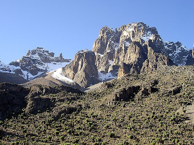
Mount Kenya

Mount Kenya is the highest mountain in Kenya and the second highest in Africa Mount Kenya is located in central Kenya, just south of the equator, around 150 kilometres /93 miles north-northeast of the capital Nairobi. Mount Kenya National Park, established in 1949, protects the region surrounding the mountain. Initially it was a forest reserve before being announced as a national park. In April 1978 the area was designated a UNESCO Biosphere Reserve. The national park and the forest reserve, combined, became a UNESCO World Heritage Site in 1997.

Mount KenyaMount Kenya is a stratovolcano formed approximately 3 million years that was active in the Plio-Pleistocene. It was covered by an ice cap for thousands of years. This has resulted in much eroded slopes and numerous valleys radiating from the centre. There are currently 11 small glaciers. The mountain is an important source of water for much of Kenya. The original crater was probably over 6,000 metres / 19,700 ft high.

The volcano was discovered by Europeans in 1849 by Johann Ludwig Krapf, but the scientific community remained doubtful about his reports of snow and ice so close to the equator. The existence of Mount Kenya was confirmed in 1883 and it was first explored in 1887. The summit was finally climbed by a team led by Halford John Mackinder in 1899. Today there are many walking routes, climbs and huts on the mountain.

The rocks that form Mt Kenya are mainly basalts, rhomb porphyrites, homilies, kenytes and trachytes. The geology of the Mount Kenya area was first considered by Joseph Thomson in 1883. After 1887 Teleki and von Hohnel climbed the mountain and described what they considered to be the crater. In 1893 Gregory's expedition reached the Lewis Glacier at 5,000 metres / 16,400 ft. He confirmed that the volcano was extinct and that there were glaciers present. The first thorough survey was not undertaken until 1966.

There are eight distinct vegetation bands from the base to the summit. The lower slopes are covered by different types of forest. Many species are endemic or highly characteristic of Mount Kenya such as the lobelias, the senecios and the rock hyrax. Because of this, an area of 715 square kilometres / 276 sq miles around the centre of the mountain is designated a National Park. The park receives over 15,000 visitors per year.

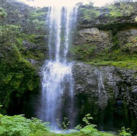
="MountMount Kenya WaterfallMount Kenya is the main water catchment area for two large rivers in Kenya. Tana is the largest river in Kenya and the Ewaso Ng'iso North. The Mount Kenya ecosystem provides water directly for over 2 million people. The Thuchi River is the district boundary between Meru and Embu. In 1988 Tana River supplied 80% of Kenya's electricity using a series of seven hydroelectric power stations and dams.

The climate of Mount Kenya has played a critical role in the development of the mountain, influencing the topography and ecology amongst other factors. It has a typical equatorial mountain climate which Hedberg described as winter every night and summer every day. Mount Kenya is home to one of the Global Atmosphere Watch's atmospheric monitoring stations.

Wednesday, December 16, 2009

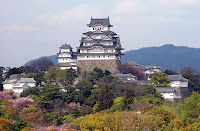
Himeji Castle

Himeji Castle is a flatland-mountain Japanese castle complex located in Himeji in Hyogo Prefecture and comprising 83 wooden buildings. It is also known as Hakurojo or Shirasagijo or White Heron Castle because of its sparkling white exterior. It was registered as the first Japanese National Cultural Treasure by UNESCO World Heritage Site and a Japanese National Cultural Treasure in December, 1993. Along with Matsumoto Castle and Kumamoto Castle, it is one of Japan's "Three Famous Castles", and is the most visited castle in Japan.

Himeji CastleHimeji is an example of the prototypical Japanese castle, containing many of the defensive and architectural features associated with Japanese castles. The tall stone foundations, whitewashed walls, and layout of the buildings within the complex are standard elements of any Japanese castle, and the site also features many other examples of typical castle design, including gun emplacements and stone-dropping holes.

One of Himeji's most important defensive elements, and perhaps its most famous, is the confusing maze of paths leading to the main keep. The gates, baileys, and outer walls of the complex are organized so as to cause an approaching force to travel in a spiral pattern around the castle on their way into the keep, facing many dead ends. This allowed the intruders to be watched and fired upon from the keep during their entire approach. However, Himeji was never attacked in this manner, and so the system remains untested.

Himeji Castle was originally built in 1346. Himeji was one of the last holdouts of the tozama daimyo at the end of the Edo period. It was held by the descendants of Sakai Tadasumi until the Meiji Restoration. In 1868, the new Japanese government sent the Okayama army, under the command of a descendant of Ikeda Terumasa, to shell the castle with blank cartridges and drive its occupiers out.

Himeji CastleHimeji CastleWhen the han system was eliminated in 1871, Himeji Castle was sold at auction. Its final price was 23 Japanese Yen which is equal to approximately 100,000 yen at today's rates in those days and in public funds. Himeji was bombed twice in 1945, at the end of World War II. Although most of the surrounding area was burned to the ground, the castle survived unharmed, with one firebomb dropped on the top floor of the castle miraculously unexploded. Castle restoration efforts began in 1956.

Himeji Castle frequently appears on Japanese television. Edo Castle the present Tokyo does not have a stay, so when an imaginary show such as Abarenbo Shogun wants a suitably impressive substitute, the producers turn to Himeji.

Tuesday, December 15, 2009

Aleppo Citadel in Aleppo

The Citadel of Aleppo is an important tourist attraction which is a site of archaeological digs and studies. It is a large medieval fortified palace in the centre of the old city of Aleppo, northern Syria. The Citadel hill dates back to middle of the 3rd millennium BC. It is occupied by many civilizations including the Greeks, Byzantines, Ayyubids and Mamluks, the majority of the construction as it stands today is thought to originate from the Ayyubid period. A great deal of protection work has taken place in the 2000s by Aga Khan Trust for Culture in collaboration with the Syrian Directorate General of Antiquities.

Aleppo CitadelThe Citadel is situated on a mound which has an elliptical base with a length of 450m and width of 325m. At the top this ellipse measures 285m by 160m with the height of this slanting foundation measuring 50m. The entire mound was covered with large blocks of gleaming limestone, some of which still remain today. The mound is surrounded by a 22m-deep and 30m-wide moat, dating from the 12th century. Notable is the fortified gateway, accessible though an arched bridge. This feature was an addition from the Mamluk government in the 16th century. A succession of five right-angle turns and three large gates with carved figures directs to main inner castle entrance. The interior are the Weapons Hall, the Byzantine Hall and the Throne Hall, with a restored decorated ceiling. The amphitheater is often used for musical concerts or cultural events.

The enormous stone bridge constructed by Sultan Ghazi over the moat led to an imposing entrance complex. Would-be assailants to the castle would have to take over six turns up a vaulted entrance ramp, over which were machicolations for pouring hot liquids on attackers from the mezzanine above. Secret passageways wind through the complex, and the main passages are decorated with figurative reliefs. The Ayyubid block is topped by the Mamluk ‘Throne Hall,’ a hall where Mamluk sultans entertained large audiences and held official functions.

Inside Citadel
Ghazi’s famous ‘palace of glory’ tragically burned down on his wedding night, but it was later rebuilt and today stands as one of the most important and impressive monuments in the citadel crown. The Ayyubids were not the first to build a palace on the citadel. Today, many fine architectural details remain from the Ayyubid period, including a spectacular entrance portal with muqarnas, or honeycomb vaulting, and a courtyard on the four-iwan system, with beautiful tiling. Laid out in traditional medieval Islamic style, the palace hammam has three sections. The first was used for dressing, undressing, and resting. The second was an unheated but warmer room, and a steam room equipped with alcoves. Hot and cold water was piped through to the hammam with earthenware pipes.

By no means was construction in the citadel confined to above-ground. Several wells penetrate down to 125m below the surface of the crown. Underground passageways connect to the advance towers and possibly under the moat to the city.

Friday, December 11, 2009

Copenhagen Opera House

The Copenhagen Opera House is the national opera house of Denmark, and among the most modern opera houses in the world. It is also one of the most expensive opera houses ever built with construction costs well over 500 million U.S. dollars. The Opera is located in Copenhagen just opposite the main castle Amalienborg at the shore of the harbor. The opera house is built in alignment with Amalienborg and Marble Church, so we can see the Marble Church over the water along the road through Amalienborg. The specific part of the island where the Opera was built is named Dokoen, which means the Dock Island.

Copenhagen Opera HouseThe house is administered by Royal Danish Theatre and is one of the best-equipped in the world. It has a main stage with five other stages directly connected, where large setups can be moved easily in and out. There are between 1492 and 1703 seats, depending on the size of the orchestra. The 1492 seats are all individually angled in order to provide the best experience.

The orchestra pit provides room for 110 musicians and the building provides excellent sound quality for the orchestra. If the pit is filled, some musicians are located below a part of the stage, which has become controversial among members of the orchestra, because this increases the sound levels beyond those acceptable in Denmark. As in the old Royal Danish Theatre in Copenhagen, the Queen has her own balcony on the left side of the auditorium, near to stage.

The foyer has been designed for comfort, based on behavioural research on operagoers maximizing the wall area for standing against, while still providing views across the entire foyer and one of the best views on Copenhagen.

The Opera has 6 main stages: 1 visible for the audience, and 5 for preparations and training. It has almost everything needed for opera, ballet etc., including stage elevators, movable balletfloors, etc. The building totals 41,000 m² and has 14 floors, of which 5 are below ground. It contains more than 1000 rooms, including a large orchestral rehearsal room. There are only approximately 1500 seats because a larger number of seats would hamper the quality of sound.
The building makes it possible to go outside on the top floor, but it is only possible to walk comfortably at the south side of the building which is opposite to the entrance. This is where the employees have their canteen, and idea behind this design is to ensure that the employees are not seen from below by the visitors.

Opera House EntranceOpera House FoyerThe building makes it possible to go outside on the top floor, but it is only possible to walk comfortably at the south side of the building which is opposite to the entrance. This is where the employees have their canteen, and idea behind this design is to ensure that the employees are not seen from below by the visitors.

The building was designed by architect Henning Larsen in close and often problematic cooperation with Maersk McKinney Moller. The building itself has an outside surface of Jura Gelb limestone. The foyer floor is Sicilian Perlatino marble. There are three very remarkable lamps in the central part of the foyer, created by the Icelandic artist Olafur Eliasson.

The wall of the auditorium towards the foyer, and the wood of the balconies, is maple wood. The ceiling inside the auditorium is made using 105,000 sheets of gold leafs, almost 100% 24 carat. Pure 24 carat wouldn't stick well enough. The floor in the main audience room is smoked oak. The balconies have been designed with holes in a very special pattern, that improve sound quality, as well as LED-based lighting that can be used in a variety of ways.

Route 903 of the Copenhagen Harbour Buses shuttles between Nyhavn and the Opera from 7-23 from Monday-Friday and from 10-23 on weekends. The opera is also served by Harbour Buses Routes 901 & 902, connecting it to various other points along the harbourfront. Of regular buses, Route 66 goes to the Opera, connecting it to the Central Station.

Thursday, December 10, 2009

Machu Picchu in Peru

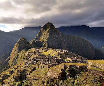
Machu Picchu is an important tourist place located on a mountain ridge over Urubamba Valley in Peru. It is a Columbian Inca site located 2,430 metres / 8,000 ft above sea level. It is 80 kilometres / 50 miles northwest of Cuzco and through which the Urubamba River flows. It is also referred to as "The Lost City of the Incas" which is one of the most familiar symbols of Inca Empire.
Machu PicchuThe Incas started building it around 1430 AD but was abandoned as an official site for the Inca rulers a hundred years later at the time of Spanish conquest of the Inca Empire. Although known locally, it was largely unknown to the outside world before being brought to international attention in 1911 by Hiram Bingham, an American historian. Machu Picchu was stated a Peruvian Historical Sanctuary in 1981 and a UNESCO World Heritage Site in 1983. Since it was not plundered by the Spanish when they conquered the Incas, it is especially important as a cultural site and is considered a sacred place.

Machu Picchu was built in classical Inca style, with elegant dry-stone walls. Its main buildings are the Intihuatana, the Temple of the Sun, and the Room of the Three Windows. These are situated in what is known by archaeologists as the Sacred District of Machu Picchu. In September 2007, Peru and Yale University reached an agreement regarding the return of artifacts which Hiram Bingham had removed from Machu Picchu in early twentieth century.

The primary archaeological treasures: the Intihuatana, the Temple of the Sun and the Room of the Three Windows. These were dedicated to Inti, their sun god and greatest deity. The Popular District, is place where the lower class people lived which includes storage buildings and simple houses. In the royalty area, the residence of the Amautas / wise persons was characterized by its reddish walls, and the zone of the Nustas / princesses had trapezoid-shaped rooms. The Monumental Mausoleum is a carved statue with vaulted interior and carved drawings. It was used for rites or sacrifices.

The Inca built a road to the Machu Picchu region. Today, tens of thousands of tourists walk the Inca Trail to visit Machu Picchu each year at Cusco before starting on a two to four day journey on foot from the Urubamba valley up through the Andes mountain range to the isolated city.
Temple of the SunIntihuatana stoneThe Intihuatana is believed to have been designed as an astronomic clock or calendar by the Incas and one of many ritual stones in South America. The Spanish did not find Machu Picchu so the Intihuatana Stone was not destroyed as many other ritual stones in Peru were. These stones are arranged to point directly at the sun during the winter solstice. The name of the stone is Quechua in inti it means 'sun'. Hence inti watana is an instrument or place to 'tie up the sun', often expressed in English as "The Hitching Post of the Sun" because the stone was believed to hold the sun in its place along its annual path in sky. At midday on March 21 and September 21, the sun stands almost above the pillar casting no shadow at all.

"Machu Picchu is the heart of our archaeological heritage and the Intihuatana is the heart of Machu Picchu. They've struck at our most sacred inheritance," said Federico Kaufmann Doig, a Peruvian archaeologist. A growing number of people visit Machu Picchu 400,000 in 2003. For this reason, there were protests against a plan to build a bridge to the site. A no-fly zone exists above the area. UNESCO is considering putting Machu Picchu on its List of World Heritage Sites in Danger.

Boulders in Cape Town

Boulders is a popular beach near Simon's Town, Cape Town in the Western Cape province of South Africa. There are larger and more scenic beaches around, as Boulders, which gets its name from the large boulders surrounding it, is fairly small. From the beach one has views over False Bay. It is world famous for its colony of African penguins / Jackass penguins.
Boulders BeachThe first penguins came to Foxy Beach only two decades ago and their number increased to more than 3000, because penguins from the surrounding islands immigrated to the beach. Although they attract hundreds of thousands of tourists every year, they can be a menace to the local inhabitants. The penguins do not stick to their beach, but like to go on safari, and can occasionally be found in neighbouring gardens and houses. A fence has been erected, but they still seem to find holes.

The penguins are seen without paying any fees, but the penguin's private beach is managed by Table Mountain National Parks and an entry fee R30 per person is charged. Alternatively, entry for those with Wild Cards is free. Boulders Beach is to enjoy a relaxed time, swimming together with penguins the only place in the world, where you can do that or walk further on and you will get to a spotting place, where you will be able to see most of the penguins from a small distance.

Going to beach is an adventure especially in summer, when it is warm and when you will share most of your time with penguins in water. You can also climb around to get to a less crowded part of the beach. Dont try to catch or touch the penguins. They are already distracted from their natural way of life by tourists and they can easily bite off a finger. Going to the beach means getting up early, because only a limited number of people are allowed onto the beach and it can be full by 10 or 11am.

Though you will see penguins here all year round you will see less during September to October as it is their time out at sea feeding up for moulting season. Moulting season is from November to December. In January adults will spend a lot of time out at sea again, feeding up for breeding season between February and August.
PenguinsTourists SwimmingDriving by car, Boulders is a popular stop on the way back from Cape Point if you have limited time. It's possible to do a circular route, driving past Boulders on the east coast, and along the west coast of the peninsula in the reverse direction. The easiest route is to drive south on M3 De Waal Drive from Cape Town. At the end of highway, turns left, and about 500m on, turn right onto M4 Main Road along east coast of the Cape Peninsula. After passing through Simons Town turn left down Bellevue Road opposite the Country Club you will see a brown sign directing you to the parking lot at the end of the road. The road is quite narrow and there is danger of accidents when going out again. The penguins here have adapted to the constant flow of humans coming to see them, so they certainly won't make way.

A more scenic alternative is to take the M3 south from Cape Town. At the end of the highway, turn right, and about 800m on through one traffic light, turn left onto Ou Kaapse Weg. Cross the scenic mountain pass you can stop for a view at the top, turning off at the Silvermine sign. On the other side, continue straight, through two traffic lights. You'll cross Black Hill, a smaller mountain pass, with views of the Indian Ocean. You descend and reach the coast road.

Take MetroRail suburban train from Cape Town to Simons Town. The station at Simons Town is about 3 kilometres from Boulders Beach; you can walk there by the Main Road southwards until you get to Bellevue Road or take a Rikis taxi from the station.

Wednesday, December 9, 2009

Sapa in Vietnam

Sa Pa or Sapa is a frontier town and district in the Lao Cai province in northwest Vietnam and 350 km north-west of Hanoi, close to the border with China. It is one of the main market towns in the area, where many ethnic minority groups such as H'mong, Dao and Tay live. The Hoang Lien Son range of mountains dominates the district, which is at the eastern extremity of the Himalayas. This range includes Vietnam's highest mountain, Fan Si Pan, at a height of 3142m above sea level. The town of Sa Pa lies at an altitude of about 1600 m.

SapaSa Pa is a quiet mountain town and home to a great diversity of ethnic minority peoples. The total population of 36,000 consists mostly of minority groups. Approximately 7,000 live in Sapa, others are scattered in small communes throughout the district. Most of the ethnic minority people work their land on sloping terraces since the vast majority of the land is mountainous. Their staple foods are rice and corn. The unique climate in Sapa has a major influence on the ethnic minorities who live in the area.

The scenery of the Sa Pa region in large part reflects the relationship between the minority people and nature. This is seen especially in the paddy fields carpeting the rolling lower slopes of the Hoang Lien Mountains. On a clear day, the impressive peak of Fan Si Pan is visible. The last major peak in the Himalayan chain, Fan Si Pan offers a real challenge to even the keenest walker, the opportunity of staggering views, and a rare glimpse of some of the last remaining primary rain forest in Vietnam.

Sapa MountainsSapa LandsGeology, climate and human activity have combined to produce a range of very distinct habitats around Sa Pa. Especially important is Sa Pa’s geographic position, at the convergence of the worlds 14 “biomes” i.e., distinct biographic areas, producing an assemblage of plant and animal species unique in the world. The Hoang Lien Mountains are home to a rich variety of plants, birds, mammals, amphibians, reptiles and insects, many only found in northwestern Vietnam. For this reason, the Hoang Lien Nature Reserve was designated in 1986, covering much of the mountain range to the immediate south of Sa Pa.

The climate of Hoang Lien Nature Reserve is unique to Vietnam. Mean annual temperature for Sa Pa town is 15.4°C, with a maximum of 29.4°C and a minimum of 1°C. The warmest months are July and August, and the coldest months are December and January. Snow falls in some years on the highest peaks. The rainy season is from May to September, with the heaviest rainfall in July and August. Mean annual rainfall is 2,763 mm, with a high of 4,023mm and a low of 2,064mm. Humidity ranges from 75 to 91 percent with a yearly mean of 86 percent.

From Hanoi it is a 9-hour train journey to Sapa. Vietnam Rail operates some of the cars, but other cars in the train are operated by private companies. Some of these cars are nicer than the standard cars. You may need to arrange with a travel agency to get tickets on these tourist cars, but any traveller can purchase tickets for the at the Hanoi train station.

Monday, December 7, 2009

Mount Kilimanjaro

Mount Kilimanjaro is a famous snow-capped mountain which has become a major destination for mountaineers and trekkers from around the world. The snows in the peak are disappearing rapidly. The height of mountain is 5,895 metres /19,340 feet from sea level. Kilimanjaro is Africa's highest peak and the world's highest free-standing mountain.

Kilimanjaro National Park protects the area above 2,700 metres / 8,850 ft, on the mountain and includes the moorland and highland zones, Shira Plateau, Kibo and Mawenzi peaks. The Park also has six corridors or rights of way through the Kilimanjaro Forest Reserve. The Forest Reserve, which is also a Game Reserve, was established in 1921; the Park was established in 1973 and officially opened in 1977.

Mount Kilimanjaro is the biggest stratovolcanoes in the world. It is a composite volcano, comprising numerous layers of lava and tephra, piled up around the vents in the shape of a cone. The lava flowed as liquid, while the tephra is material that was sprayed into the air and fell as blocks, cinders and small particles. The lava is rich in silica and viscous. Recent studies suggest the last eruptions on the mountain were between 150,000 and 200,000 years ago.

This region does not experience the limits of winter and summer weather, but rather dry and wet seasons. January and February are the warmest months, April and May are the wettest months, June and July are the coolest months, and August and September are the driest months. January, February, and September are considered to be the best months to climb Kilimanjaro in terms of weather.

KilimanjaroKilimanjaro in morningThe routes to the Uruhu peak cross different ecological zones. The temperature varies with the altitude and time of day. Mount Kilimanjaro has five major ecological zones, each approximately 3,280 feet / 1,000 m in altitude. Each zone is subject to a corresponding decrease in rainfall, temperature and life as the altitude increases. The average temperature is around 70°F to 80°F / 27°C to 32°C at the base of the mountain. From there, the temperatures will decrease as you move through Mount Kilimanjaro's ecological zones. Uruhu Peak night time temperatures can range between 0°F to -15F /-18°C to -26°C. Due to Mount Kilimanjaro's great height, the mountain creates its own weather. Therefore when you climb you should always be prepared for wet days and cold nights.

The closest International Airport is Kilimanjaro / JRO, and if coming from Europe, KLM Northwest Airline has a daily non-stop flight from Amsterdam to JRO. If you are coming from Nairobi, Kenya, you can fly with Kenya Airways. Alternatively, you can schedule shuttle buses, which are at 8am and 2 pm daily and its a 5-6hrs bus ride.