Social Icons

Pages

Tuesday, August 24, 2010

Zugspitze Mountain in Germany

The Zugspitze is highest mountain in Germany at 2,962 metres above sea level. It is located on Austrian border beside the town of Grainau in district of Garmisch Partenkirchen in federal-state of Bavaria. On Austrian side lies the town of Ehrwald in district of Reutte, Tyrol. There is a cog railway leading from tourist resort of Garmisch-Partenkirchen to Zugspitzplatt from where a cable car runs to peak. There are also two cable cars that go to peak from the base of mountain one ascends from German side of mountain at lake Eibsee and other ascends from Austria near Ehrwald. The peak is regularly crowded with tourists. The details of Zugspitze are explained in world tour guides below.

Zugspitze MountainFor those wishing to reach the summit under their own power, various hiking and ski trails can also be followed to the top. Hiking to the top from the base takes between one and two days, or a few hours for the very fit. Food and lodging is available on some trails. In winter the Zugspitze is a popular skiing and snowboarding destination, with several slopes on both sides. The Zugspitzplatt is Germany's highest ski resort, and thus normally has sufficient snow throughout the winter.
The border between Germany and Austria goes right through the mountain. There used to be a border checkpoint at the summit. But since Germany and Austria are now both part of the Schengen zone, the border crossing is no longer staffed. The Zugspitze belongs to the Wetterstein range in the Northern Limestone Alps. It gets its name from the many avalanche passages on its steep north slopes. At the Zugspitzes summit is the Munchner Haus a mountain hut, a facility built by the German Alpine Club. For more than a hundred years, the summit has also had a weather station, which nowadays also gathers data for the Global Atmosphere Watch.

Shortly after World War II the US military took over the Schneefernerhaus for the exclusive use of US military and civilian employees. Room rates, including meals, were US $ 1 per day. Ski lessons were available, taught by Austrians and Germans, at a cost of US $ 0.25 per hour. The first recorded ascent to the summit was accomplished by a team of land surveyors on the 27th of August, 1820. The team was led by Lieutenant Josef Naus who was accompanied by two men named Maier and G.Deutschl. However, local people had conquered the peak over 50 years earlier, according to a 1770 map discovered by the Alpenverein.

On 7 January 1882 the first successful winter assault on Zugspitze was accomplished by F. Kilger, H. and J. Zametzer and H. Schwaiger. Climbing up Zugspitze can involve several routes. The large difference in elevation between Garmisch-Partenkirchen and summit is 2 200 m making the climb a challenge even for trained mountaineers. On German side from Garmisch-Partenkirchen climbers go either through Hollental or Reintal. The way through Reintal is easiest but also longest and takes 8 to 10 hours. This path goes through the Partnachklamm a scenic gorge then through Reintal up to Zugspitzplatt, a barren plateau from there up to the summit. Climbers can stay for night at two alpine huts Reintalangerhutte or Knorrhutte.

Zugspitze MountainZugspitze Mountain
The more popular but harder route is through Hollental. It starts at Hammersbach near Garmisch goes through Hollentalklamm a similar gorge up to Hollentalangerhutte where one can take a meal or stay for night. It then crosses Hollentalferner remnants of a small glacier. After that it traverses a wall with help of iron ladders and steps. Via ferrata equipment is recommended for that part. Over Irmerscharte it reaches the summit. This path will take 7 to 8 hours.

From Austrian village of Ehrwald there are also two variants. One goes straight through the Western Flank, which is the shortest route overall, but rather hard. It includes via ferrata and there is a hut called Wiener Neustadter Hutte by Austrian Alpine Club. An easier path leads via Ehrwalder Alm across a small pass called Gatterl joining Reintal path at Knorrhutte. The Zugspitzes exact height was a matter of debate for quite a while. Given figures ranged from 2 960 m to 2 970 m but it is now generally accepted that peak is 2962 m above sea level as a result of a survey carried out by the Bavarian land survey office. The lounge at new cafe is named 2962 for this reason.

Monday, August 23, 2010

Megyeri Bridge

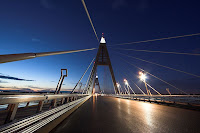
The Megyeri Bridge previously known as Northern M0 Danube Bridge is a cable stayed bridge that spans River Danube between Buda and Pest respectively west and east sides of Budapest, capital of Hungary. It is an important section of M0 ringroad around Budapest. The details of Megyeri Bridge are explained in world tour guides below.

Megyeri BridgeThe bridge cost 63 billion forints approximately US$ 300M to build and was officially opened on September 30, 2008 however National Transport Authority of Hungary has only issued temporary permits because of disagreement among suburban cities surrounding the bridge. A naming poll to determine new name of recently-built bridge caused controversy and received media attention when American comedians Stephen Colbert and Jon Stewart won. The total length of bridge is 1862m. Structurally it is composed of five parts. They are Left quayside inundation area bridge 148m, Main Danube-branch bridge cable stayed 590m with a span of 300m, Szentendre island inundation area bridge 559m, Szentendre Danube-branch bridge 332m and Right quayside inundation area bridge 218m.

The Ministry of Economic Affairs and Transport of Hungary organized a public vote online to solicit possible names for new bridge. The three names with most votes as well as suggestions from local governments, cartographers, linguists and other experts were to be reviewed by government committee before a final name for bridge was chosen. New nominations were accepted until August 21, 2006, and voting ended on September 8, 2006, with Stephen Colbert winning with 93,163 votes, and Jon Stewart and Zrinyi close behind with 85,171 and 83,966 votes, respectively.

On August 1, 2006 Reuters reported that top candidate according to the online poll was the Chuck Norris hid named for American action star Chuck Norris. On August 11, 2006 American satirist Stephen Colbert discussed story on his comedy program The Colbert Report instructing his viewers to visit polling website and vote for him instead of Norris. The next day the number of votes for him had grown 230 times and he now asked his viewers to follow a link from his own Colbert Nation website to avoid all that illegible Hungarian. Colberts site also indirectly offered techniques for stuffing the ballot box as users of their forums created several automated scripts to cast multiple votes for Colbert.

Megyeri BridgeMegyeri Bridge
On August 15, 2006 he repeated his call to be voted top of Hungarian poll and by August 22, 2006 Stephen Colbert hid was in first with 17 million votes about 14 million votes ahead of second-placed Zrinyi hid named after Croatian Hungarian national hero Miklos Zrinyi and about 7 million more than entire population of Hungary. The same day site announced a new round of voting which would require registration to participate and Colbert asked his viewers to call off dogs requesting on his website that fans stop using scripts to vote. Despite this Stephen Colbert hid remained in the top position on the website in the second round.

On September 14, 2006 Andras Simonyi the ambassador of Hungary to the United States announced on The Colbert Report that Stephen Colbert had won the vote. Unfortunately for Colbert Ambassador Simonyi declared that under Hungarian law Colbert would have to be fluent in Hungarian and would have to be deceased in order to have the bridge named for him. However after saying the rules could most likely be bent he invited Colbert to visit Hungary and view the construction in person and gave him a Hungarian passport and a 10,000 HUF Bill with an approximate value of as the ambassador put it fifty dollars, fifty good US dollars. Colbert promptly tried to bribe him with said money.

Thursday, August 19, 2010

Kochi Castle in Japan

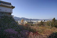
Kochi Castle is a castle located in Kochi, Kochi Prefecture, Japan. Next to the Battle of Sekigahara in 1600 Kochi Castle was constructed in what was then the province of Tosa. It was built by Yamanouchi Kazutoyo who took control of the province after the Tokugawa victory. The castle was constructed as part of the move from Urado to the more defensible Otakasa area. The details of Kochi Castle are explained in world tour guides below.

Kochi CastleThe construction of Kochi Castle was begun in 1601 and was completed in 1611. Much of original fortress burned down in 1727. It was reconstructed between 1729 and 1753 in original style. The castle underwent major restoration from 1948 to 1959. Though no battles were fought at castle it is remarkable because castle is the original structure and not a post war replica. It is also the only castle in Japan to retain both its original tenshu or keep and its palace. In fact, it is the only castle to have all the original buildings in the honmaru or innermost ring of defense, still standing.

Two previous attempts were made to build castles on Otakasa Hill. Both failed. The first attempt was by Otakasa Matsuomaru sometime during the late Heian or Kamakura periods. The second was in 1588 by the conqueror of Shikoku Chosokabe Motochika. The area around the hill at this time was extremely swampy due to the influx of alluvial sediments from the Kagami River. Consequently, previous builders were never successful in establishing a permanent fortress on the site where Kochi Castle stands today.

As one of only twelve intact castles in Japan, Kochi Castle was popularly called a National Treasure before the 1950 National Treasure Protection Law was enacted. After the law was passed, it was demoted to the status of Important Cultural Asset. Kochi Castle can be seen in the background of the animated film I Can Hear the Sea by Studio Ghibli during the class reunion scene. The castle figures prominently in the film The Harimaya Bridge. Key scenes in the movie take place in the courtyard just inside the Oteman Gate on the top level of the castle itself, and at the entrance to the castle grounds just outside the Oteman Gate.

Two rivers, the Kagami River and the Enokuchi River, form the outer moat of the castle. The tower is five stories high and sits atop Otakasa Hill, commanding an extensive view of the city. It rises above the Kaitokukan palace which was constructed in the Shoin style of the Edo period. The castle retains this structure today and has been fitted with period-appropriate items in the lower rooms. In addition to a tearoom, Genkan entrance area and latrine the Kaitokukan contains eight traditional rooms, ranging in size from three to twelve tatami. It is surrounded by a veranda on the east and south sides. The Kaitokukan also burned during the fire of 1727, but it was not repaired until 1747, with work completed in 1749.

Kochi CastleKochi CastleKochi Castle is located in downtown Kochi. The main entrance is directly across from the west entrance of the Obiyamachi shopping area. Visitors are asked to remove their footwear before entering the building. Slippers are provided. As the castle is quite old, the tatami rooms are visible but not accessible. There is a small museum area with information entirely in Japanese. This museum houses several cultural artifacts of the Tosa region not native to the castle itself.

The upper rooms of the tower are all empty, but visitors are allowed to climb to the top. There is a railing but no net around the balcony. Handicap access is extremely limited as the approach to the castle involves many steps. There is no elevator. The castle grounds are now a public park, and a popular location in spring for hanami. They contain the Prefectural Library and the Kochi Literary Museum, in addition to statues of notable scions of the Yamanouchi family.

Tuesday, August 17, 2010

Roskilde Cathedral

Roskilde Cathedral is a cathedral in the city of Roskilde on Island of Zealand in eastern Denmark. It was the first Gothic cathedral to be built of brick and its construction encouraged the spread of this Brick Gothic style throughout Northern Europe which was built during 12th and 13th centuries and incorporates both Gothic and Romanesque architectural features in its design. It was the only cathedral in Zealand until the 20th century. The details of Roskilde Cathedral are explained in world tour guides below.

Roskilde CathedralRoskilde Cathedral has been the main burial site for Danish monarchs since the 15th century. As such, it has been significantly extended and altered over time as individual rulers have added multiple burial chapels. Following the Reformation in 1536 the Bishops residence was moved to Copenhagen, and he from then on held the title Bishop of Zealand. Royal coronations normally took place in Copenhagens Church of Our Lady or the chapel of Frederiksborg Palace. It is a major tourist attraction bringing in over 125,000 visitors annually. Since 1995 the cathedral has been listed as a UNESCO World Heritage Site.

The cathedral has been the home of one of Denmark leading boys choirs, the Roskilde Cathedral Boys Choir. The choir soon celebrating its 20th birthday is a key resource in the parish youth work. All choristers go to normal school but meet up 2-3 times a week to rehearse. Every second year the choir travels abroad destinations being as different as New Zealand, Scandinavia, England, Greenland, France and Canada. Roskilde was named as the new capital of Denmark by King Harald Bluetooth about the year 960. A small timber church was built there and dedicated to the Holy Trinity. King Harald was buried inside the little church at Roskilde but no trace of it has ever been located.

In about 991 Roskilde was made seat of Bishop of Roskilde under supervision of Archbishop of Hamburg, who had responsibility for converting pagan kingdoms of Scandinavia. The bishop was responsible for island of Zealand, Scania, and islands to south including Rugen off coast of northern Germany. The church was built in Romanesque style with half rounded interior arches to support the flat interior ceiling. A three sided stone monastery was constructed adjoining cathedral on north side for monks and others associated with cathedral. Bishop Svend succeeded in bringing an important relic, skull of St. Lucius, an early pope, who became patron saint of the cathedral. The skull is now located in Catholic Cathedral of St. Ansgar in Copenhagen.

Bishop Jacob Erlandsen built a school at cathedral for education of poor children in 1249. In 1310 a Lady Chapel was added onto cathedral of present mausoleum which houses tombs of many of Denmarks recent royal family. Bishop Peder Jensen Lodehat forcibly removed body of Queen Margrethe I from Soro Abbey in 1414 and interred her with great pomp inside cathedral. In 1439 work began on interior of cathedral, proceeding as far as the choir. But on 14 May 1443 a terrible fire swept through city and burned cathedral. It was damaged so severely that it was not rededicated until 1464, built in footprint of earlier building. King Christian I paid for addition of a new Chapel of Three Kings as part of overall reconstruction.

Roskilde CathedralRoskilde Margrethe GraveThe cathedral was last bastion of Catholicism in Sjaelland but in 1536 Lutheran Superintendent of Zealand moved to Copenhagen, although Roskilde was still officially cathedral. The decline of Roskilde was precipitous, all the monasteries, church schools, chapter houses, were closed and property snapped up by crown or local noble families. The cathedrals gigantic crucifix and other Catholic symbols were taken down or destroyed. Because the church was a royal resting place, the cathedral was spared the savage looting of churches that accompanied the Reformation in other parts of the country. Superintendents quickly were titled bishops again and Bishop of Zealand continued to live and work from Copenhagen until Zealand Diocese was split from Copenhagen in 1920s.

In 1635-6 two west towers were raised and given now familiar tall thin spires clad in copper. The towers house six bells. The oldest surviving bell was cast in 1508 by Hans Jensen. Johannes Fastenowe cast two bells in 1511 paid for by Bishop Johan Ravensberg. The largest bell Stormklokken hangs in the north tower. Burchado cast a bell in 1594 that hangs with the Jensen and smaller Fastenowe bell in the south tower. A magnificent Royal Door on the west front was carved by Geert Barchmann. The new portal was used only on state occasions visitors enter by the south door. The beautiful entrance was later moved to Holmen Church in Copenhagen. In 1645 Zealand's bishop ordered the recording of all baptism, marriages, and deaths throughout Zealand and many of Denmark's earliest vital records exist as a result.

Thursday, August 12, 2010

Lake Titicaca

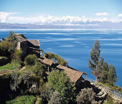
Lake Titicaca is a lake located on the border of Peru and Bolivia. It sits 3,811 m above sea level making it the highest commercially navigable lake in the world. By volume of water it is also the largest lake in South America. The details of Lake Titicaca are explained in world tour guides below.

Lake TiticacaThe lake is located at the northern end of the endorheic Altiplano basin high in the Andes on the border of Peru and Bolivia. The western part of the lake lies within the Puno Region of Peru, and the eastern side is located in the Bolivian La Paz Department. The lake is composed of two nearly separate sub-basins that are connected by the Strait of Tiquina which is 800 m across at the narrowest point. The larger sub basin Lago Grande has a mean depth of 135 m and a maximum depth of 284 m. The smaller sub basin Winaymarka has a mean depth of 9 m and a maximum depth of 40 m. The overall average depth of the lake is 107 m.

Lake Titicaca is fed by rainfall and meltwater from glaciers on the sierras that abut the Altiplano. Five major river systems feed into Lake Titicaca. In order of their relative flow volumes these are Ramis, Coata, Ilave, Huancane and Suchez. More than 20 other smaller streams empty into Titicaca, and the lake has 41 islands, some of which are densely populated. The cold sources and winds over the lake give it an average surface temperature of 10 to 14 °C. In the winter mixing occurs with the deeper waters, which are always between 10 to 11 °C.

The origin of name Titicaca is unknown. It has been translated as Rock Puma for its resembling shape of a puma hunting a rabbit, combining words from the local languages Quechua and Aymara and as well as translated as Crag of Lead. The southeast quarter of lake is separate from main body the Bolivians calling it Lago Huinaymarca and larger part Lago Chucuito. In Peru these smaller and larger parts are referred to as Lago Pequeno and Lago Grande respectively. Titicaca is notable for a population of people who live on the Uros a group of 42 or so artificial islands made of floating reeds. These islands have become a major tourist attraction for Peru drawing excursions from lakeside city of Puno.

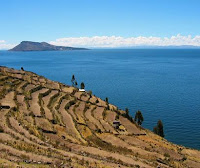
Amantani is another small island on Lake Titicaca populated by Quechua speakers. About 800 families live in six villages on the roughly circular 15 square kilometres island. There are two mountain peaks called Pachatata and Pachamama, and ancient ruins on the top of both peaks. The hillsides that rise up from the lake are terraced and planted with wheat, potatoes, and vegetables. Most of the small fields are worked by hand. Long stone fences divide the fields, and cattle, sheep, and alpacas graze on the hillsides.

AmantaniTaquile IslandTaquile is a hilly island located 35 kilometres east of Puno. It is narrow and long and was used as a prison during the Spanish Colony and into the 20th century. In 1970 it became property of the Taquile people, who have inhabited the island. Pre Inca ruins are found on the highest part of the island, and agricultural terraces on hillsides. Situated on the Bolivian side of lake with regular boat links to Bolivian town of Copacabana, Isla del Sol is one of the lakes largest islands. Geographically, the terrain is harsh; it is a rocky, hilly island. There are no motor vehicles or paved roads on the island. The main economic activity of the approximately 800 families on the island is farming, with fishing and tourism augmenting the subsistence economy.

Isla de la Luna is situated east from the bigger Isla del Sol. According to legends that refer to Inca mythology Isla de la Luna is where Viracocha commanded the rising of the moon. Ruins of a supposed Inca nunnery occupy the oriental shore. Suriqui lies in the Bolivian part of Lake Titicaca. Suriqui is thought to be the last place where the art of reed boat construction survives, at least as late as 1998. Craftsmen from Suriqui helped Thor Heyerdahl in the construction of several of his projects, such as the reed boats Ra II and Tigris, and a balloon gondola.

Wednesday, August 11, 2010

Peterhof Palace

The Peterhof Palace is actually a series of palaces and gardens laid out on the orders of Peter the Great. These Palaces and gardens are sometimes referred as the Russian Versailles. The palace ensemble along with the city centre is recognised as a UNESCO World Heritage Site. The details of Peterhof Palace are explained in world tour guides below.

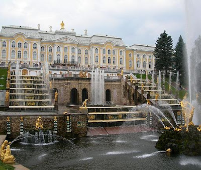
Peterhof PalaceThe dominant natural feature of Peterhof is a 16m high bluff lying less than a hundred metres from the shore. The so called Lower Gardens, at 1.02 km² comprising the better part of Peterhofs land area, are confined between this bluff and the shore stretching east and west for roughly 200m. The majority of Peterhofs fountains are contained here are several small palaces and outbuildings. East of the Lower Gardens lies the Alexandria Park with 19th century Gothic Revival structures such as the Kapella.

Atop the bluff, near the middle of the Lower Gardens, stands the Grand Palace. Behind of it are the comparatively small Upper Gardens. Upon the bluffs face below the Palace is the Grand Cascade. This and the Grand Palace are centrepiece of entire complex. At its foot begins the Sea Channel one of the most extensive waterworks of Baroque period, which bisects Lower Gardens. The Grand Cascade is modelled on one constructed for Louis XIV at his Chateau de Marly which is likewise memorialised in one of the parks outbuildings.

At the centre of cascade is an artificial grotto with two stories faced inside and out with hewn brown stone. It currently contains a modest museum of the fountains history. One of the exhibits is a table carrying a bowl of fruit, a replica of a similar table built under Peters direction. The table is rigged with jets of water that soak visitors when they reach for the fruit, a feature from Mannerist gardens that remained popular in Germany. The grotto is connected to the palace above and behind by a hidden corridor.

The fountains of Grand Cascade are located below the grotto and on either side of it. Their waters flow into a semicircular pool, the terminus of the fountain-lined Sea Channel. In the 1730s the large Samson Fountain was placed in this pool. It depicts the moment when Samson tears open the jaws of a lion representing Russia victory over Sweden in the Great Northern War, and is doubly symbolic. The lion is an element of the Swedish coat of arms and one of the great victories of the war was won on St Samson Day. From the lions mouth shoots a 20m high vertical jet of water the highest in all of Peterhof. This masterpiece by Mikhail Kozlovsky was looted by the invading Germans during the Second World War. A replica of the statue was installed in 1947.

The greatest technological achievement of Peterhof is that all of the fountains operate without the use of pumps. Water is supplied from natural springs and collects in reservoirs in the Upper Gardens. The elevation difference creates the pressure that drives most of the fountains of the Lower Gardens, including the Grand Cascade. The Samson Fountain is supplied by a special aqueduct, over four km in length, drawing water and pressure from a high-elevation source. The expanse of the Lower Gardens is designed in the formal style of a garden a la francaise of the 17th century. Although many trees are overgrown, in the recent years the formal clipping along the many allees has resumed in order to restore the original appearance of the garden.

Peterhof PalacePeterhof PalaceThe Chesma Hall is decorated with twelve large paintings of the Battle of Chesma, a stunning naval victory of the Russo-Turkish War, 1768-1774. These were painted between 1771 and 1773 by the German artist Jacob Philipp Hackert. His first renderings of great battle scenes were criticised by witnesses as not showing realistically the effect of exploding ships flying timbers, great flames, smoke, and fireballs. Catherine II assisted the artist by exploding a frigate in harbour of Livorno, Italy, for benefit of Hackert, who had never seen a naval battle first hand. Hackert also did not research actual positions of Russian and Turkish forces during battle so scenes depicted are somewhat fanciful, but do effectively convey drama and destruction of naval warfare.

The East and West Chinese Cabinets were decorated between 1766 and 1769 to exhibit objects of decorative art imported from East. The walls were decorated with imitation Oriental patterns by Russian craftsmen, and hung with Chinese landscape paintings in yellow and black lacquer. Another room positioned at the centre of palace bears the name of Picture Hall. Its walls are almost entirely covered by a series of 368 painting mostly of variously dressed women differing in appearance and even age yet most were drawn from a single model.

Monday, August 9, 2010

Queen Victoria Building

The Queen Victoria Building is a late nineteenth century building by the architect George McRae in the central business district of Sydney, Australia. It is also called as QVB. The Romanesque Revival building is 190 metres long by 30 wide, and fills a city block, bounded by George, Market, York and Druitt Streets. Designed as a shopping centre, it was later used for a variety of other purposes until its restoration and return to its original use in the late twentieth century.

Queen Victoria Building
The site of the Queen Victoria Building was the location of the George Street Markets, and was selected for the construction of a grand government building. Architect George McRae designed the QVB in the ornate Romanesque Revival style with the express purpose of employing a great number of skilled craftsmen who were out of work due to a severe recession. The building was completed in 1898 and named the Queen Victoria Building after the monarch.

The completed building included coffee shops, showrooms and a concert hall. It provided a business environment for tradesmen such as tailors, mercers, hairdressers and florists. The concert hall was later changed to a municipal library and building was partitioned into small offices for Sydney City Council. The building steadily deteriorated and in 1959 was threatened with demolition. It was restored between 1984 and 1986 by Ipoh Ltd at a cost of $86 million, under the terms of a 99-year lease from the City Council and now contains mostly upmarket boutiques and brand-name shops.

Ipoh finished a $26 million restoration in 2009. The changes include new shop fronts, glass signage, glazed balustrades, new escalators connecting ground, first and second levels and new colour schemes. The dominant feature is the central dome, consisting of an interior glass dome and a copper-sheathed exterior, topped by a domed cupola. Smaller domes of various sizes are on the roofline, including a pair overtopping each end of the rectangular building.

Stained glass windows, including a cartwheel window depicting the arms of the City of Sydney, allow light into the central area, and the roof itself incorporates arched skylights running lengthways north and south from the central dome. The intricate colonnades, arches, balustrades and cupolas make the exterior a visual feast of Victorian fussiness. The building consists of four main shopping floors, the top three pierced by voids protected by decorated cast-iron railings. Much of the tilework, especially under the central dome, is original, and the remainder is in keeping with this style. Underground passageways lead off to Town Hall Station at the southern end, and to a food court at the north.

Queen Victoria BuildingQueen Victoria BuildingTwo mechanical clocks, each one featuring dioramas and moving figures from moments in history, can be seen from the adjacent railed walkways. The Royal Clock, designed by Neil Glasser and made by Thwaites & Reed of Hastings in England, shows scenes of English royalty from King John signing the Magna Carta to the execution of King Charles I. Activating on the hour, the Royal Clock is accompanied by a trumpet voluntary written by Jeremiah Clarke. The Great Australian Clock, designed and made by Chris Cook, weighs four tonnes and stands ten metres tall. It includes 33 scenes from Australian history, seen from both Aboriginal and European perspectives. An Aboriginal hunter circles the exterior of clock continuously representing never-ending passage of time.

The building also contains many memorials and historic displays. Of these two large glass cases stand out. The first display case contains an Imperial Chinese Bridal Carriage made entirely of jade and weighing over two tonnes only example found outside China. The second is a lifesize figure of Queen Victoria in replica of her Coronation regalia, and surrounded by replicas of British Crown Jewels. Her enthroned figure rotates slowly throughout the day, fixing onlooker with her serene and youthful gaze.

Tuesday, August 3, 2010

US Bank Tower

US Bank Tower is a 310.3 m or 1,018 ft skyscraper at 633 West Fifth Street in downtown Los Angeles, California. It is also called as Library Tower and First Interstate Bank World Center. The details of U.S. Bank Tower are explained in world tour guides below. It is the tallest building in the state, the tenth-tallest building in the United States, the tallest west of the Mississippi River and as of December 2009 40th tallest building in the world.

US Bank TowerThe local building codes require the building to have a helipad it is also the tallest building in the world with a roof top heliport. Until the construction of Taipei 101 it was also the tallest building in a major active seismic region; its structure was designed to resist an earthquake of 8.3 on the Richter scale. It consists of 73 stories above ground and two parking levels below ground.

The Construction of U.S. Bank Tower began in 1987 with completion in 1989. The building was designed by Henry N. Cobb of the architectural firm Pei Cobb Freed & Partners and cost $350 million to build. It is one of the most recognizable buildings in Los Angeles often used in establishing shots for the city in films and television programs.

The building is also known as Library Tower because it was built as part of the $1 billion Los Angeles Central Library redevelopment area following two disastrous fires in 1986 and its location across the street. The City of Los Angeles sold air rights to the developers of the tower to help pay for the reconstruction of the library. The building was also known for a time as First Interstate Bank World Center but the name Library Tower was restored after First Interstate Bancorp merged with Wells Fargo Bank. In March 2003 the property was leased by U.S. Bancorp and the building was renamed U.S. Bank Tower.

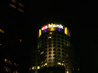
US Bank TowerUS Bank TowerThe tower has a large glass crown at its top that is illuminated at night. The crown is lighted with red and green during the Christmas holiday season and lit red around Saint Valentine's Day. It is also lit with purple and gold when the Los Angeles Lakers are playing in the NBA Playoffs and blue and white on Opening Day for the Los Angeles Dodgers and when the Dodgers are playing in the playoffs. The crown was also lit with red, white and blue during the July 4 holidays, but that practice ended in 2003.

On February 28, 2004, two 23 m or 75 ft U.S. Bank logo signs were installed on the crown amid controversy for their effect on the aesthetic appearance of the building much like previous First Interstate Bank logos were placed on the crown between 1990 and 1998. First Interstate Banks I logo on crown was in the 1993 Guinness Book of World Records for highest placed logo. On June 16, 2004, the 9/11 Commission reported that the original plan for the September 11 attacks called for the hijacking of ten planes, one of which was to be crashed into the building.